
Arrested Development
Erin strengthened on Thu, but had a plateau in development Thu night. She is expected to become a powerful major hurricane over the weekend. Direct US impacts cannot be ruled out yet.

IMPORTANT NOTE: I had intended to post the below update on Fri morning US time, but unfortunately came down with a stomach virus, so I was unable to edit it and post before Shabbat.
(My family and I observe the Jewish Sabbath, also called Shabbat - which means I don’t turn on/off electrical items including computers and phones for 24 hours. Instead, I immerse myself in the peaceful atmosphere that Shabbat provides - having special Shabbat meals with my family, singing Shabbat melodies around the table, spending time bonding with them, engaging in a Jewish form of meditation/mindfulness and also learn Jewish wisdom contained in the Torah.)
Anyway, on to the post… again, it expresses my thoughts on Erin as of Fri morning US time. I plan to post an update by Saturday night on Erin, especially given that she has surpassed all expectations and strengthened rapidly to a Category Five hurricane!
*************************************************************************************************************
Tropical Storm Erin’s road to Tropical Cyclone Greatness has been slow and bumpy so far. Erin strengthened on Thu, with peak winds reaching 70 mph by evening. However, Erin’s cloud pattern most of yesterday was a CCC (Central Cold Cover) pattern, which generally indicates a plateau in intensity until convection can focus closer to its inner core.

Satellite loop of Erin from around 10AM Thu to 2AM Fri, showing Erin evolving from an amorphous CCC (Cold Cloud Cover) pattern to the beginnings of inner core formation with convection being focused closer to her center.
Fri morning recon data and satellite loops indicate strong signs of Erin developing that much anticipated inner core, and she is poised to strengthen significantly into a Category Two or Three hurricane by Sunday.
Erin has been persistently tracking faster and south of the model consensus for several days now. While Erin started gaining latitude in the past 24 hours since it turned WNW, recent recon fixes show there is no sign of this tendency abating.
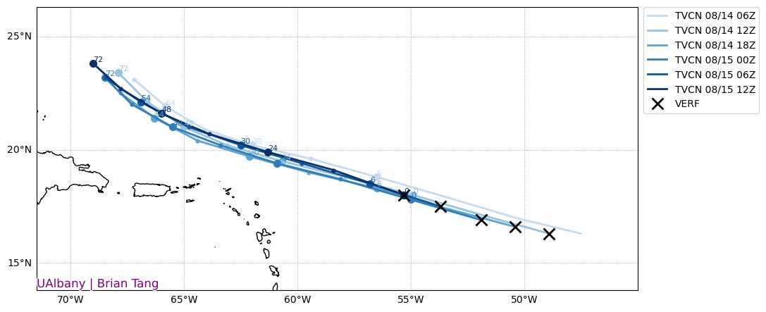
In fact, comparing Erin’s 12z (7 AM ET) position to the most reliable ensemble guidance we have (the ECMWF EPS), she has moved faster than about 80% of ensemble members showed and only about 10-15% of ensemble members were further south and west of Erin’s 12z position.
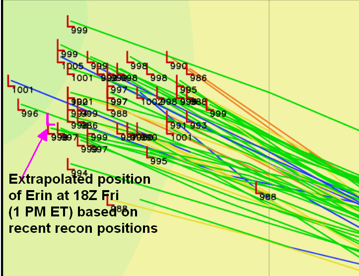
Moreover, extrapolating Erin’s expected position at 18Z (based on motion between the last few reconnaissance plane “fixes” of her position) shows that Erin is likely to be on the fast and southwest edge of the EPS spread by 18z.
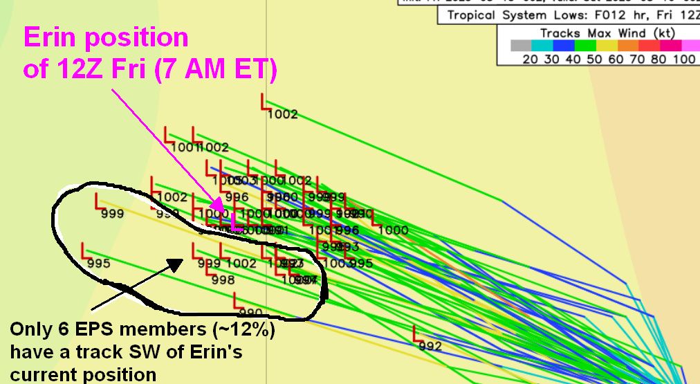
An important benchmark to watch for is to see if Erin passes over/south of 21N when it crosses 65W longitude and over/south of 23N when it crosses 70W. Only a few EPS members from the 0Z Friday run (around 10%) show Erin getting within 100 miles of the North Carolina Outer Banks, and these members nearly all pass over or south of both of the above benchmarks.
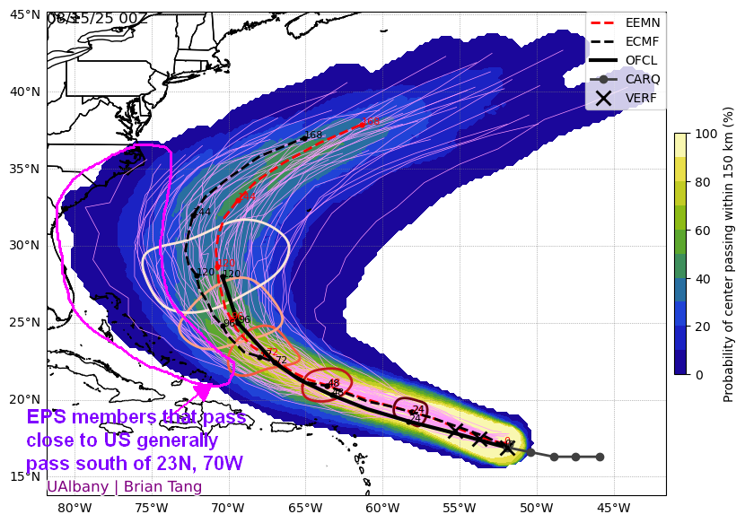
ECMWF ensemble (EPS) forecast tracks from the 50 members of the ensemble, initialized on Fri morning, Aug 15 (0Z). This graphic shows the spread of possible tracks, with the most likely tracks shown in yellow, green and lighter blue colors. Less likely, but still possible track scenarios are shown in darker blue colors.
The machine learning models are split, with most reliable models showing a strong enough SE Canada upper low to create a ridge weakness and allow Erin to safely recurve between the US East Coast and Bermuda. However, the Pangu (shown below) and the FourCastNet ML models show a weaker/further north upper low over SE Canada and allow Erin to get perilously close to the US.
The reason for the difference between the Pangu/FourCastNet scenario and the strong SE Canada upper/weaker west Atlantic ridge scenario of the AIFS and other ML models most likely is related to their different handling of an upper low north of Alaska and a trough south of Alaska. The Pangu and co. have a less deep upper low north of Alaska (blue and green colors in the graphic below) which is centered further north, which forces the blocking high pressure over Greenland (darker red and grey colors in the graphic below) to be weaker and shoved further east.
Additionally, Pangu and co. have the trough south of AK slightly deeper and situated a little farther west than AIFS and other ML models. This allow the ridge near the Rockies to be centered a little further north and also be more amplified/sharp. The more amplified ridge, in turn, allows for a slightly deeper trough over the Great Lakes and a notably stronger west Atlantic ridge between Bermuda and the northeast US.
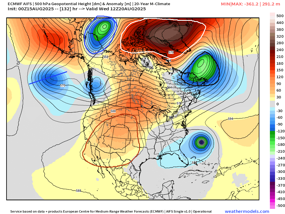
AIFS and Pangu Machine Learning model forecasts of 500 mb height anomaly valid for 7AM ET Wed, Aug 20, showing the location of Erin off the Southeast US coast and also indicating upper level wind patterns that would steer Erin.
Now, the Pangu (which is a skillful model on large scale patterns like upper level winds/heights, only slightly behind AIFS) and FourCastNet (a less skillful model) are outliers compared to the remainder of ML models and ensemble forecasts like EPS and GEFS.
What makes me more concerned is the AIFS is trending in the direction of the Pangu regarding an east-shifted high-latitude upper low north of Alaska and weaker Greenland block. Furthermore, another highly skillful ML model, Microsoft’s Aurora model, has been trending toward the Pangu scenario of a deeper and west-shifted trough south of Alaska.
Now for an outline of potential impacts from Erin. First things first… people with interests in the southeast Bahamas and Turks and Caicos Islands need to keep a very close eye on updated National Hurricane Center forecasts for Erin. While official forecasts currently indicate Erin passing around 150 miles northeast of these islands on Mon and these islands are not in the National Hurricane Center (NHC) cone, the NHC track has shifted significantly further southwest since Thursday.
Moreover, a closer pass within 75 miles of the southeast Bahamas and Turks and Caicos Islands could still bring tropical storm force winds and perhaps even gusts to over hurricane force Mon into early Tue. There are some reliable models, especially the hurricane-specific HAFS-A and B models, that are over 100 miles southwest of the official NHC forecast. Given Erin’s persistent tendency to stay on the southern side of the model spread, I wouldn’t be surprised to see continued southwestward shifts in official forecasts in the next 24-36 hours.
While the most likely scenario remains that Erin recurves sharply northeast by mid-next week several hundred miles off the East Coast of the US, a track much closer to the coast remains a distinct possibility if Erin remains on the southern side of the forecast model spread in the next day or two, and if the consensus of forecast models shifts toward a weaker upper low in southeast Canada and a stronger ridge of high pressure between Bermuda and the northeast US coast.
I’ll have an update by Sunday. In the meantime, keep watchin’ the skies and the heavens.